Aldergrove and the east Langley areas will be carved up and moved into new provincial electoral districts under new legislation introduced at the legislature Thursday, Oct. 29. (See new electoral areas maps at bottom of this page.)
Justice Minister Suzanne Anton tabled legislation to adopt the recommendations of the latest B.C. Electoral Boundaries Commission and create the two new constituencies to reflect high-growth areas of provincial population, bringing the number of MLAs in the legislature to 87.
The commission recommended changes to boundaries to 48 existing constituencies, after public hearings since it proposed the changes this spring to balance population. It was restricted by a law that prevents the elimination of electoral districts in areas outside the urban southwest.
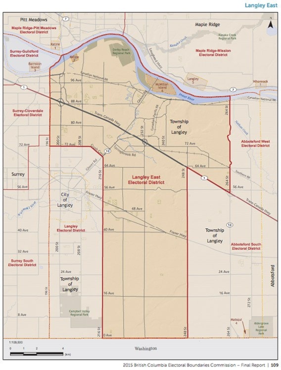
The areas of Aldergrove and east Langley which were formerly part of the Fort Langley-Aldergrove riding will be divided into three newly named or reconfigured ridings: Abbotsford South, Langley East and Abbotsford West.
Fort Langley-Aldergrove will cease to exist and the riding of Langley will include the area from 72 Avenue to the U.S. border, between 196 and 216 Streets.
Abbotsford South will take in the area from 248 Street to Boundary Road in Chilliwack, between the U.S. border and Hwy. 1.
Abbotsford West will include the area between the Fraser River and Hwy. 1, from 264 Street to the Abbotsford-Mission Hwy.
Langley East is a "T" shaped riding, which will run from the Fraser River to the U.S. border, with the top part of the "T" including the area from 264 to 196 Streets, and the bottom part including the area between 216 and 248 Streets.
The latest boundaries leave a wide range of populations to be represented by a single MLA. The lowest populations are Stikine with 20,616 and North Coast with 22,382. At the other end of the scale are Vernon-Monashee, Vancouver-Fraserview and Vancouver-Kingsway, all with more than 62,000 people.
The last review in 2008 recommended that an urban population shift should result in a reduction of one seat in the Cariboo-Thompson region and one in northern B.C. The government intervened keep those seats and increase the total constituencies from 83 to 85.
The B.C. Liberals and NDP agreed then that northern constituencies could not get any larger and still be represented by a single MLA.
The 2008 review added seats in the Okanagan, Fraser Valley, Surrey, Burnaby-Tri-Cities and downtown Vancouver.
The commission's report and maps are available on its website at bc-ebc.ca/reports
-with files from Tom Fletcher

Map of new Abbotsford South electoral district shows Aldergrove and east Langley areas included in proposed 2017 election boundaries.

Proposed boundaries of Abbotsford West include a portion of Langley Township.