A revamped map of federal riding boundary changes has been tabled in Canada’s House of Commons, and the local changes are significantly different from those proposed last year.
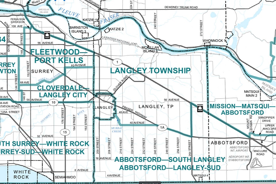
The new boundaries would divide Langley and Aldergrove among three different ridings, all of which would also extend into either Surrey or Abbotsford.
Most of Langley Township north of Fraser Highway or 40th Avenue would be placed in a riding called Langley Township. That riding would include a slice of northeastern Surrey, as well as Barnston Island. The riding would also include Willoughby, Walnut Grove, Fort Lagnley, Glen Valley, Milner, and Murrrayville.
South of that would be a riding dubbed Abbotsford-South Langley. It would include Brookswood, south Langley below 40th Avenue or Fraser Highway, Aldergrove, and much of South Abbotsford, as far east as Sumas Way.
The third Langley-area riding would be Cloverdale-Langley City, which will include all of Langley City and a significant chunk of Surrey, from 56th Avenue in the south as far north as 80th Avenue. The Serpentine River will form part of the riding boundary, dividing it from Fleetwood-Port Kells.
The new maps, which are changed every 10 years, have not been approved by the House of Commons yet.
But they are very different from the proposed new ridings unveiled last spring by the Federal Electoral Boundaries Commission for B.C.
In that original plan, Langley north of Highway One was to be part of a sprawling riding dubbed Pitt Meadows-Fort Langley. It was to include parts of Langley, Surrey, Maple Ridge, Pitt Meadows, and even Port Coquitlam, and stretched across the Fraser River and the Pitt River.
Langley MP Tako Van Popta called it “a bit of a surprise,” while Pitt Meadows-Maple Ridge MP Marc Dalton called it “a dog’s breakfast.”
When the Boundary Commission held hearings in Langley, they heard from a number of locals who opposed a riding that was on both sides of the Fraser River.
Electoral boundaries in Canada are changed every 10 years after the census, with non-partisan commissions drawing up the maps and collecting public feedback. The riding boundaries have to be changed to ensure the number of residents per riding remains roughly the same, for political parity in the House of Commons.
British Columbia has gained one more MP in this riding redistribution.
READ MORE: Go back to drawing board on quirky Pitt Meadows-Langley federal riding: public feedback
READ MORE: New riding of Pitt Meadows-Fort Langley a dog’s breakfast, says MP
According to the commission’s report, that was a major issue that resulted in changes.
“Two issues figured most prominently in the public submissions: whether a major waterway should be crossed within an electoral district, and whether a municipality as a whole should be situated within an electoral district,” the commission’s report says.
– More to come
- MATTHEW LAT STORY TIP
Have a story tip? Email: matthew.claxton@langleyadvancetimes.com
Like us on Facebook and follow us on Twitter.