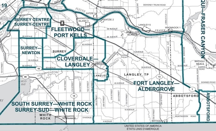
A proposal to split the current Langley riding in two was further revised in the final report of the Commission on Redistribution of Electoral Districts.
As previously reported in The Times, the proposal would see Langley City become part of a Cloverdale-Langley riding while most of the Township, including Fort Langley and Aldergrove, would become part of the Fort Langley—Aldergrove riding.
However, the recommended boundaries of the two ridings have been revised from the version which appeared in The Times on Thursday.
Here are the details as reported in the commission report:
Cloverdale—Langley
Population: 108,519
Consisting of the City of Langley;
Part of the Township of Langley lying southerly and westerly of a line commencing at the intersection of the westerly limit of the municipality with the Trans-Canada Highway; easterly along the highway to 208 Street; southerly along 208 to the Willowbrook Connector; then southwesterly along the connector to Mufford Crescent; southeasterly along the crescent to the northerly limit of the City of Langley at 62 Avenue.
Part of the City of Surrey commencing at the intersection of the easterly
limit of Surrey with 88 Avenue; then westerly along the avenue to 176 Street (Pacific Highway); then southerly along 176 to the Serpentine River; then southwesterly along the river to the easterly production of 68 Avenue; then westerly along said production and 68 Avenue to 144 Street; then southerly along the street to Highway No. 10 (56th Avenue); then easterly along the highway to 192 Street; then southerly along the street to
56 Avenue; then easterly along the avenue to the easterly limit of the city; then northerly along said limit to the point of commencement.
Fort Langley—Aldergrove
Population: 94,883
Consisting of the Township of Langley, excepting that part lying southerly and westerly of a line commencing at the intersection of the westerly limit of the township with the Trans-Canada Highway (Highway No. 1); then easterly along the highway to 208 Street; then southerly along the street
to the Willowbrook Connector; then southwesterly along the connector to Mufford Crescent; then southeasterly along said crescent to the northerly limit of the City of Langley at 62 Avenue.
The Katzie Indian Reserve No. 2, McMillan Island Indian Reserve No. 6 and Matsqui Indian Reserve No. 4; and part of the City of Abbotsford lying
westerly of a line commencing at the intersection of the southerly limit of Abbotsford with Mount Lehman Road; then northerly along the road to Huntingdon Road; then westerly along the road to Mount Lehman Road; then generally northerly along said road to the Trans-Canada Highway (Highway No. 1); then northwesterly along the highway to Bradner Road; then generally northerly along the road to River Road; then northerly in a straight line to the southeast corner of Maple Ridge.
The two Langley ridings are part of a Canada-wide reshuffling to reflect population growth that has added five new electoral districts to the Lower Mainland, bringing the total to 26.
Before the current riding was put in place in 2004, Langley was part of two larger ridings, one of which also included part of Abbotsford.
The other had Langley City and a small portion of the Township connected to a riding which was mostly made up of South Surrey and White Rock.
The commission report still has to be debated at a Parliamentary Committee and the final vote in the House of Commons will not be taken until May or June.