Kinder Morgan has opted to bypass developed neighbourhoods in Walnut Grove where its existing oil pipeline runs in favour of a new route for its proposed twinned pipeline — along the CN rail right-of-way.
While the route choice allows Trans Mountain pipeline planners to dodge possible conflict with thousands of homeowners who live near the current line, it’s likely to mean sharper focus on the environmental risk of a rupture that could send heavy crude oil into the Fraser and Salmon Rivers.
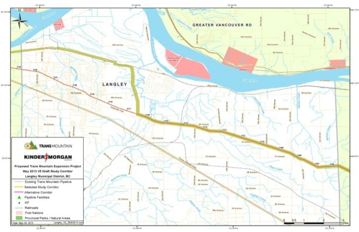
The map of the study corridor through Langley, Surrey, Abbotsford and Chilliwack was unveiled Friday.
The completed $5.4 billion pipeline twinning, if approved, would carry 890,000 barrels of oil per day — triple the current capacity — with most of the increase consisting of diluted bitumen for export via tankers through Burrard Inlet.
While the new pipeline to Burnaby’s Westridge Terminal would closely follow its 60-year-old predecessor through most of the Fraser Valley, it breaks with the past at about 224 Street in Langley, just after it crosses the Salmon River. It then cuts north, to the west of Fort Langley and beside the meandering Salmon River, to reach the CN rail line.
The existing pipeline crosses into Langley from Abbotsford at about the 7000 block, then heads gradually northwest along the ridge above Glen Valley. It crosses the Salmon River just south of Belmont Golf Course and then goes to the north of Telegraph Trail into Walnut Grove.
The new pipeline would head almost straight north from a location just west of the golf course.
The detour would allow construction crews to avoid the Walnut Grove neighbourhood, which has sprung up since the original pipeline was built.
From there, the new route runs west along the rail line and the South Fraser Perimeter Road through Surrey to a new tunneled crossing of the Fraser River downstream of the Port Mann Bridge.
Along the way it would tread along the edge of newly-created Surrey Bend Regional Park and past industrial properties in Port Kells. But few homeowners would be affected.
“A lot has changed in the last 60 years,” said Greg Toth, senior project director for the Trans Mountain expansion project. “Following the existing pipeline is not practical.”
So much has changed that even the old Port Mann Bridge and the section of Highway 1 approaching it in Surrey did not exist when when the original line was built from northern Alberta in 1952 and 1953.
Toth won’t say what route is proposed north of the Fraser. That’s to be revealed on Thursday.
But the Surrey and Langley maps suggest it won’t go through residential yards in Coquitlam, either.
It is likely the preferred new route would run from Cape Horn west along the CP rail line, with two alternate routes toward Burnaby identified as the Highway 1 and Lougheed Highway corridors.
— with files from Frank Bucholtz